


File:Aerial view of Ptolemais.webp
No higher resolution available.
Aerial_view_of_Ptolemais.webp (798 × 565 pixels, file size: 146 KB, MIME type: image/webp)
Summary
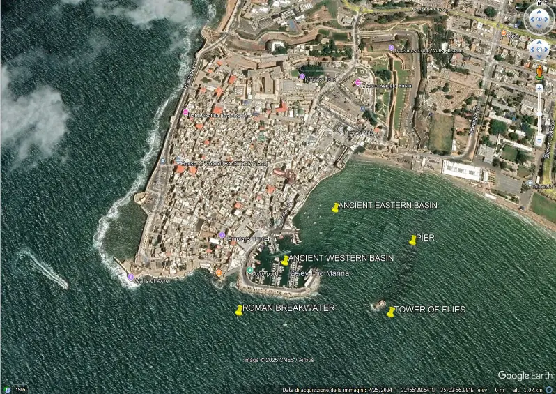
Aerial view of Ptolemais with indicated the ancient western port, the ancient eastern port, the long pier with the remains of a tower, and the Roman breakwaters (both submerged), indicated by the yellow pins. Notice the small curved pier in the ancient western basin, mentioned by Maria Valtorta, and the larger ancient eastern basin, largely silted up due to the progradation of the coastline. The ancient western basin is also partially silted up.
File history
Click on a date/time to view the file as it appeared at that time.
| Date/Time | Dimensions | User | Comment | |
|---|---|---|---|---|
| current | 21:58, 19 September 2026 | 798 × 565 (146 KB) | Terranovas67 (talk | contribs) | Figure 2. Aerial view of Ptolemais with indicated the ancient western port, the ancient eastern port, the long pier with the remains of a tower, and the Roman breakwaters (both submerged), indicated by the yellow pins. Notice the small curved pier in the ancient western basin, mentioned by Maria Valtorta, and the larger ancient eastern basin, largely silted up due to the progradation of the coastline. The ancient western basin is also partially silted up. |
You cannot overwrite this file.
